LA CIttà antica

🇬🇧 A hypothetical reconstruction ofthe city o/Lilybaeum between the end ofthe Punic Age and the Roman conquest.
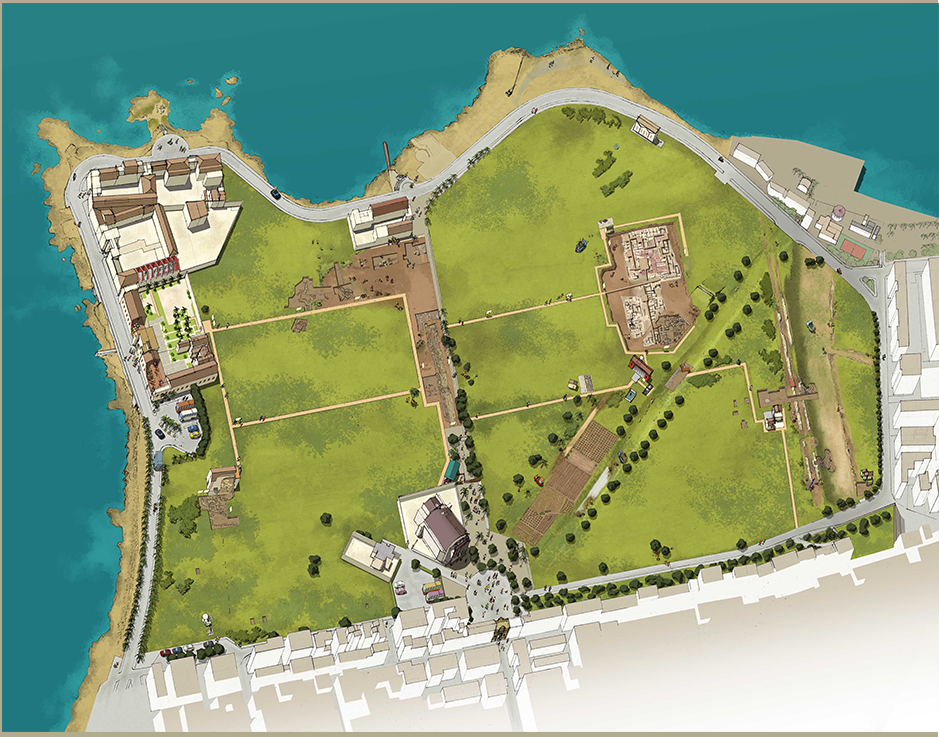
🇮🇹 LA CITTÀ ANTICA
“Splendidissima civitas”, così Cicerone descrive Lilybaeum nel 75 a.C. durante la sua permanenza nella città come questore.
Stando a questa testimonianza, la città doveva essere, oltre che ben fortificata e difesa, anche urbanisticamente sviluppata ed economicamente florida.
L’impianto urbano, di tipo greco, si basava su una griglia stradale di assi principali (plateiai: dal gr. platùs, via larga) e secondari (stenopoi: dal gr. stenòs, via stretta), che definivano isolati rettangolari, stretti ed allungati.
11 tessuto viario seguiva la conformazione naturale del promontorio che occupava per intero: le strade principali erano parallele alla costa meridionale e delimitavano isolati disposti in senso N-S, che prospettavano su di esse con il lato breve. Nel settore N-E della città il sistema degli isolati ruotava di 90°, forse per adattarsi alle pendenze del terreno e allo smaltimento delle acque in direzione della costa.
Uno degli assi viari principali era la Plateia “Aelia”, che si conserva nella città di Marsala come via XI Maggio. La città antica, infatti, si trova in gran parte sotto l’attuale Marsala, dove gli scavi hanno portato alla luce resti di abitazioni dislocate in vari punti dell’odierno centro urbano.
🇬🇧 THE ANCIENT CITY
“Splendidissima civitas” – a most splendid city – is how Cicero described Lilybaeum in 75 BC during his stay in the city as a quaestor (the lowest ranking regular magistrate in ancient Rame, whose traditional responsibility was the treasury). Judging by this testimony, the city must have not only been very well fortified and protected but a/so very well planned and developed, with a very flourishing economy.
The urban pian was based on a road-grid made up of main axes (plateiai: from Greek platùs, wide road) and secondary axes (stenopoi: from Greek stenòs, narrow road), which created narrow and extended rectangular blocks.
The road pattern followed the natural conformation of the promontory which it fully covered: the main roads were parallel to the southern coast and marked the limits of the blocks set in N-S direction, which overlooked on them with their short side. In the N-E area ofthe town, the system of blocks rotated of 90°, probably to conform to the land slope and the water draining towards the coast.
One of the main streets was the Plateia “Aelia”, corresponding to the present via XI Maggio in Marsala city.
The most of the ancient city is located under present-day Marsala, where the excavations have exposed only the remains of isolated houses scattered in various parts of today s urban centre.